Tony Nusco, who is imployed by Maritime Services, has spent more than three decades mapping the harbour floor, making sure shipping lanes are clear for the giant cruise ships as well as commercial and navy vessels.
Mr Nusco and his team of three from Sydney Ports have all but completed the first three-dimensional digital map of the hidden depths of the harbour using a ”multibeam echo sounder” system, bought by the NSW government for $750,000.
The system fires 512 sonar rays to the bottom, building up an intricate picture of the harbour floor.
The picture that has emerged includes six significant shipwrecks and a number of mysterious holes that plunge 20 metres deeper than the level of the harbour floor.
One such hole, 45 metres deep, is located less than 10 metres offshore from Balls Head at Waverton on the northern side of the harbour, west of the Harbour Bridge.
The deepest part of the shipping channel is just west of the bridge, off Dawes Point, to a depth of 40 metres.
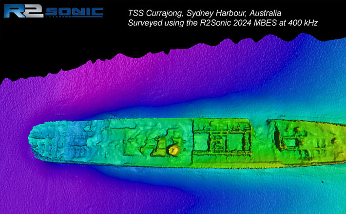
East of the bridge, off Bradleys Head, lies the harbour’s biggest and most intact wreck, the TSS Currajong, a collier that was sunk in 1910 after being hit by the Cairns-bound SS Wyreema, a 6000-tonne passenger liner.
The Currajong lies in about 30 metres of water right in the middle of the shipping lane.
”Countless water craft pass straight over the top of the Currajong every year and many would probably have no idea what is below them,” said Mr Nusco on his hydro surveyor launch. ”It was lucky for us and for Sydney that the Currajong was sunk in one of the deepest parts of the harbour.”
Read more: http://www.smh.com.au/environment/secrets-plumbed-on-harbour-floor-20110430-1e1xf.html#ixzz1LBIc4JFj