TLDR: Sydney Harbour is a drowned river valley, 19 kilometres long and 55 square kilometres in area, with an average depth of 13 metres and a deepest point of about 46 metres. It holds more recorded fish species than the entire Mediterranean Sea, and the bridge above it stands 134 metres high and is held together by roughly six million hand-driven rivets.
Sydney Harbour is one of the most photographed stretches of water on earth and one of the least understood. Most people who live beside it could not tell you how deep it is, how it was formed, or how many species live in it, and the answers are more interesting than the guesses.
This guide collects the facts about Sydney Harbour and the Sydney Harbour Bridge, with the sources for each. We have run skippered charters across this water for two decades and it still surprises us.
How deep is Sydney Harbour?
Sydney Harbour has an average depth of 13 metres, and its deepest point is around 46 to 47 metres, in the stretch of water near the Harbour Bridge between Dawes Point and Blues Point.
The average depth figure comes from the NSW Government’s estuary data for Sydney Harbour, which also classifies the harbour as a drowned river valley and records an estuary volume of 376,400 megalitres. The maximum depth of about 46.5 metres comes from published estuary research, including the review “Sydney Harbour: what we do and do not know about a highly diverse estuary” in *Marine and Freshwater Research*.
Depth varies enormously across the harbour, which is the reason the single-number answer is unsatisfying. The shallow bays around the edges run to only a few metres. The main shipping channels are dredged and maintained far deeper. And the drowned valley that the harbour sits in is deeper still beneath the sediment: research on the lower estuary found the bedrock palaeo-valley drops from roughly 40 metres below present sea level at the Harbour Bridge to more than 90 metres below sea level out at the mouth. In other words, the ancient river canyon under the harbour is roughly twice as deep as the water you can see.
For a sense of scale, the Harbour Bridge arch stands 134 metres above the water. The bridge is nearly three times taller above the surface than the harbour is deep below it.
How big is Sydney Harbour?
The harbour covers roughly 55 square kilometres of water and runs 19 kilometres inland from the entrance between North Head and South Head to the head of the estuary. Its perimeter, once you trace every bay, cove and inlet, is 317 kilometres of shoreline, which is why it feels so much larger than a 55 square kilometre figure suggests. All three figures are for Port Jackson, the harbour’s formal name.
At high tide the estuary holds about 562 million cubic metres of water. That volume is the origin of one of Australia’s more charming units of measurement: the sydharb, used informally to express the capacity of dams and reservoirs as multiples of Sydney Harbour. When you hear that a dam holds “four Sydney Harbours”, this is the number behind it.
The harbour is a drowned river valley
Sydney Harbour is not a bay that filled with water. It is a river valley that drowned.
The NSW Government classifies the harbour as a drowned valley estuary, and its shape is the giveaway. The branching, dendritic pattern of coves and inlets, and the sandstone cliffs dropping straight into deep water, are the signature of a river system, not a coastline. The valley was carved into Hawkesbury sandstone by a river running east to the sea. When sea levels rose at the end of the last glacial period, the ocean pushed up the valley and flooded it, leaving the ridges as headlands and the tributary valleys as the bays we now call Rose Bay, Mosman Bay and Middle Harbour.
That geology is also why the harbour is so useful. A flooded river valley gives you deep water very close to shore, sheltered from the ocean swell, with a narrow, defensible entrance. It is the reason a settlement was established here rather than at Botany Bay, and the reason the harbour supports both container shipping and swimming beaches within a few kilometres of each other.
Sydney Harbour has more fish species than the Mediterranean Sea
This is the fact that surprises people most, and it is true.
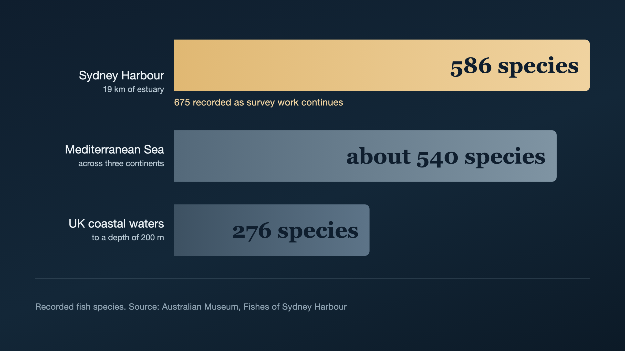
The Australian Museum’s Sydney Harbour fish database records 586 species of fish in the harbour. For comparison, roughly 540 species have been recorded across the entire Mediterranean Sea, and about 276 in UK coastal waters to a depth of 200 metres. A body of water 19 kilometres long holds more fish diversity than a sea spanning three continents. The Museum’s more recent count has since risen to 675 species as the survey work continues.
Fish are only part of it. The Australian Museum’s broader Sydney Harbour biodiversity work puts the total number of species recorded in the harbour at more than 3,000, spanning invertebrates, algae, corals and everything else.
The reason is a collision of currents. The warm East Australian Current runs down the coast carrying tropical species south, and cooler temperate waters meet it here, so the harbour picks up species from both. Add the sheltered bays, the seagrass beds, the rocky reefs and the sandstone drop-offs, and you have an unusual number of distinct habitats packed into a small area. On a charter you will routinely see fish schooling under the boat in water clear enough to watch them, and in winter you will sometimes see humpback whales at the Heads on their migration.
Are there sharks in Sydney Harbour?
Yes. Sydney Harbour is home to a range of shark species, including the bull shark, which moves into the harbour and up the rivers in the warmer months, along with wobbegongs, Port Jackson sharks and other harmless bottom-dwelling species that most swimmers never notice.
In practice this is much less alarming than it sounds. Sydney Harbour has a large number of netted swimming enclosures precisely because people swim in it constantly, at places like Balmoral, Parsley Bay, Nielsen Park, Manly Cove and Redleaf. Incidents are extremely rare, and the general local advice is the same as anywhere: swim in netted enclosures where they exist, avoid swimming at dawn and dusk, avoid murky water and river mouths after heavy rain, and do not swim alone in deep water far from shore.
On a charter, swim stops are made in sheltered bays with the crew watching the water, which is a considerably more controlled setting than an open-water swim.
There are shipwrecks on the harbour floor
Beneath a harbour this busy for this long, there is a great deal of history. Dozens of wrecks lie on the floor of Sydney Harbour, ranging from colonial-era sailing vessels through to steamships and small craft, and a number of them are protected heritage sites.
Some are accessible to qualified divers with the appropriate permissions, and some are protected and off-limits. The wrecks sit alongside a considerable amount of other history down there: discarded ballast from sailing ships, the remains of old wharves and jetties, and material dumped over two centuries of working port operations.
Sydney Harbour islands
The harbour holds a scattering of islands, most of them small, most of them with a long and layered history. The best known are Fort Denison, the fortified islet with the Martello tower off Mrs Macquaries Point; Goat Island, the largest of the inner harbour islands, with convict-era buildings and a long working-harbour past; Cockatoo Island, a UNESCO World Heritage-listed convict site and former shipyard at the junction of the Parramatta and Lane Cove rivers; and Shark Island, Clark Island, Rodd Island, Spectacle Island and Snapper Island.
Several are national park islands that can be visited by ferry or private vessel, and several are popular charter destinations, particularly Shark Island and Clark Island, which have picnic areas and swimming. If you want to include an island stop in a charter, it usually needs a landing booking arranged in advance.
Two of the harbour’s islands are not islands any more. Garden Island, the naval base off Potts Point where you will see the Navy’s ships alongside, was joined to the shore by reclamation when the graving dock was built, and Darling Island at Pyrmont was absorbed into the peninsula and now gives its name to the Darling Island precinct. Both kept the name long after the water around them disappeared, which is why you will find islands on a Sydney Harbour map that you can walk to.
The traditional owners of Sydney Harbour
The land and water around Sydney Harbour is the Country of the Eora people, and the harbour’s foreshores are the traditional lands of several clans, including the Gadigal on the southern shore, the Cammeraygal on the lower north shore around Cammeray and Kirribilli, and the Wangal on the southern side of the Parramatta River to the west.
These clans lived on and from this harbour for tens of thousands of years before European arrival, fishing from bark canoes, and the evidence is still visible along the foreshore in rock engravings, shell middens and shelter sites, many of them within sight of the water on a charter. Aboriginal place names survive across the harbour, and the harbour itself remains culturally significant Country.
Sydney Harbour Bridge facts
When was the Sydney Harbour Bridge built?
Construction started on 28 July 1923 and finished on 19 January 1932. The bridge opened to the public on 19 March 1932, after eight and a half years of work.
The opening is famous for going wrong. Before the New South Wales Premier could cut the ribbon, a man in military uniform rode forward on horseback and slashed it with a sword, declaring the bridge open in the name of the people of New South Wales. The ribbon was tied back together and the official ceremony proceeded.
How high is the Sydney Harbour Bridge?
The top of the arch stands 134 metres above the water. The two pairs of granite-faced pylons at each end of the arch stand 89 metres high. The bridge is the tallest steel arch bridge in the world.
How long is the Sydney Harbour Bridge?
The bridge is 1,149 metres long in total, and the arch itself spans 503 metres between its bearings.
How much steel is in it?
About 52,800 tonnes of steel in the whole structure, of which roughly 39,000 tonnes is in the arch alone. It is held together with approximately six million hand-driven rivets, every one of them placed by hand, which is the detail that best conveys what building this thing in the twenties actually involved.
How much did it cost, and who built it?
The bridge cost AU£6.25 million. It was designed and built by Dorman Long and Company of Middlesbrough, England, working to a design developed with the New South Wales Department of Public Works, and it was not fully paid off for decades after it opened.
Sixteen workers died building it
Sixteen men were killed during the construction of the Sydney Harbour Bridge. By the standards of major infrastructure projects of the era that number was considered low, which says a great deal about the era. There is a memorial to them, and the figure is worth remembering the next time you cruise underneath.
Painting it really is a never-ending job
The cliche is true. The bridge carries roughly 485,000 square metres of steelwork that needs protecting from salt air, and a single coat takes about 30,000 litres of paint. It has been maintained continuously since it opened.
How many people cross it?
The bridge carries eight lanes of road traffic plus two railway tracks, a footpath and a cycleway. Recorded daily traffic has run to more than 160,000 vehicles a day, on a structure designed and built before the second world war, which is a considerable engineering compliment.
The best view of it is from underneath
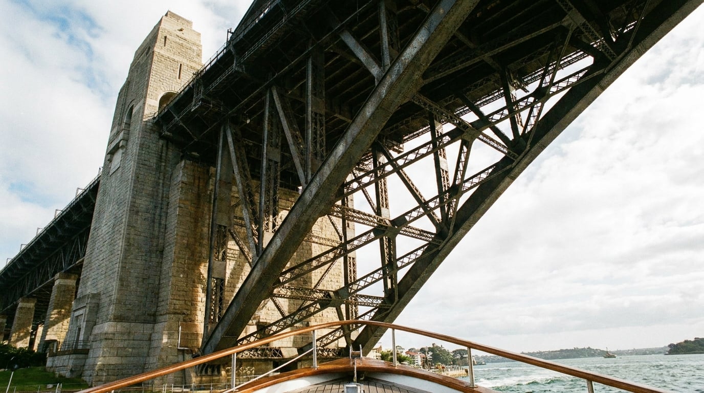
Predictably, we think so. Most people see the bridge from a car on it or from a viewpoint beside it. From a boat, you pass under the arch and get the scale of it from below, with 134 metres of steel directly overhead, and you can see the pylons, the hangers and the rivet lines from a vantage point almost nobody uses. It is the single most requested part of a Sydney Harbour charter and it takes about thirty seconds to understand why.
Sydney Harbour questions, answered
How deep is Sydney Harbour?
The average depth is 13 metres and the deepest point is around 46 to 47 metres, in the water near the Harbour Bridge between Dawes Point and Blues Point. Depth varies widely, from a few metres in the shallow bays to the maintained shipping channels.
How big is Sydney Harbour?
About 55 square kilometres of water, running 19 kilometres inland from the Heads, with 317 kilometres of shoreline once every bay and cove is traced. It holds roughly 562 million cubic metres of water at high tide.
Is Sydney Harbour man-made?
No. It is a natural drowned river valley. A river carved the valley into sandstone, and rising sea levels at the end of the last glacial period flooded it. Sections of the foreshore have been reclaimed and modified, but the harbour itself is natural.
Why is Sydney Harbour famous?
Partly the setting, with the Opera House and the Harbour Bridge together in one frame, and partly the geology, because a drowned river valley gives you deep sheltered water, dramatic sandstone headlands and dozens of bays and beaches inside a working city.
How many fish species live in Sydney Harbour?
The Australian Museum’s fish database records 586 species, with a more recent count of 675. That is more than the entire Mediterranean Sea, which has around 540. Total recorded species in the harbour across all groups exceeds 3,000.
Are there sharks in Sydney Harbour?
Yes, including bull sharks in the warmer months, along with wobbegongs and Port Jackson sharks. Incidents are very rare, and there are netted swimming enclosures at many harbour beaches. Swim in netted areas, avoid dawn and dusk, and stay out of murky water after heavy rain.
When was the Sydney Harbour Bridge built?
Construction ran from 28 July 1923 to 19 January 1932, and the bridge opened on 19 March 1932.
How high is the Sydney Harbour Bridge?
The arch stands 134 metres above the water, and the pylons are 89 metres high. It is the tallest steel arch bridge in the world.
How long is the Sydney Harbour Bridge?
1,149 metres in total, with an arch span of 503 metres.
How many rivets are in the Sydney Harbour Bridge?
Approximately six million, all hand-driven.
How many islands are in Sydney Harbour?
There are several, the best known being Fort Denison, Goat Island, Cockatoo Island, Shark Island, Clark Island, Rodd Island, Spectacle Island and Snapper Island. Several are national park islands that can be visited, and a few are popular charter stops. Two more kept the name but lost the water: Garden Island and Darling Island were both joined to the shore by reclamation.
Who are the traditional owners of Sydney Harbour?
The harbour is the Country of the Eora people, with the Gadigal on the southern shore, the Cammeraygal on the lower north shore and the Wangal to the west along the Parramatta River.
See it from the water
The harbour reads completely differently from a boat. Private charters run from $250 per hour with a qualified skipper included, so nobody needs a licence, and you can be under the bridge within minutes of leaving the wharf. Tell us your date and your numbers and we will do the rest.
Call Eastcoast Sailing on 1300 883 023 or send through your date and guest numbers for a charter quote.